Interesting Tech Projects
Archive for September, 2009
Map Scales and Printing with Mapnik
Sep 22nd
Mapnik is a nice open source library for generating maps. The typical data source is OpenStreetMap style data stored in a PostgreSQL/PostGIS database. This post examines how to understand and control the map scale and generate maps suitable for printing.
Map Scales
A map scale looks something like 1:1000. This means that for every 1 inch on the map there are 1000 inches in the real world. The units don’t matter, for example it also means that 1 meter on the map is 1000 meters in the real world. The value 1000 shown in this example is called the Scale Denominator.
Maps (in the context of this discussion) are generated using pixels. This is true even if printing because ultimately the printer has to print the pixels onto the paper (assuming a raster output). At low resolutions the pixels will be easily seen. Not so at high resolutions.
It is therefore useful for us to know the size of a pixel in meters. If we know this then we can work out the map scale and set the map scale. More >
OpenStreetMap and Beaches of the Rich and Famous
Sep 1st
In Malibu, Calif. there have long been disputes between the rich and famous and the public over access to certain beaches. One of these is Trancas Beach (a.k.a. Broad Beach).
In the 100 or so houses along this beach are the homes of some of the most famous people in Hollywood. Under the California Constitution (Article X, Section 4) the public is allowed access to certain areas of beach, but the rich and famous apparently want to keep it all for themselves. They even bulldozed the sand to protect their homes but ruined the public section, before being made to undo the damage.
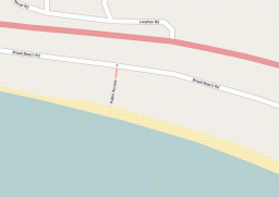
This beach has two public access walkways, but they can be hard to find. They are located between houses and are narrow. According to some reports the local residents try to obsure the locations and put up false signs to deter people.
Last weekend (August 2009) I went to the beach armed with my GPS unit. I recorded the western public access and I have now added it to OpenStreetMap. Within a few minutes it was rendered (showing the location, steps and the gate).
Now everyone will be able to put this onto their maps and GPS units, easily find this public access point and enjoy free parking and a quiet beach!
